
I read an article yesterday about the impact of global warming of night-time temperatures. They are significant. The article also talked about night temperatures generally warming faster than daytime temperatures. That made me wonder … where and how is this happening in the U.S. — especially in recent decades?
Fortunately, both high and low temperatures are reported for all 344 climate divisions in the lower 48 states of the U.S. I decided to look just at the data since 1985, in order to focus on what’s been happening recently (a bit more than the last three decades). The process is actually pretty simple: for each climate division, I fit a straight line to the post-1985 diurnal temperature range, that being the high temperature minus the low temperature.
Here are the results, with red circles marking divisions where daytime has been warming faster than nighttime, blue circles where night has warmed faster than day, and larger dots marking more pronounced differences:

Most of the country has indeed warmed faster at night recently, but not all. The southwest has gone the other way, and in many regions where the trend is as expected (night faster than day) the effect is slight. In the upper midwest (North Dakota and Minnesota), and along the eastern seaboard, we see what I expected with night warming considerably faster than day.
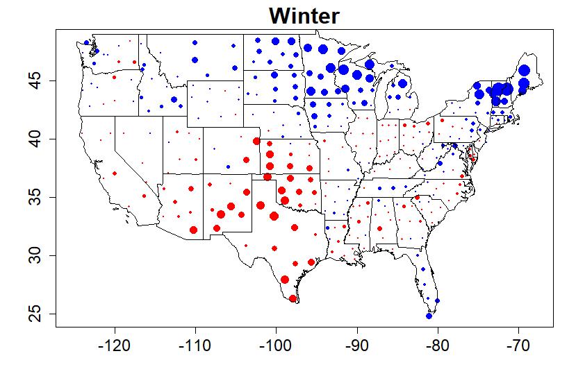
I also wondered, how do these patterns vary throughout the year? So I did the same analysis, but using only months for a single season.
The wintertime pattern is similar, but more pronounced in northern states:
In spring, however, extra nighttime warming covers the entire southeast prominently:

Summer shows a marked difference between the eastern U.S. and the western:

In autumn, much, in fact most, of the country shows faster daytime warming than nighttime. Strong faster-at-night warming is confined to the Pacific northwest and the mid-Atlantic coast:

I’ll emphasize that these results are for the last 3+ decades. The geographical patterns are quite interesting. What they mean … I don’t know.
This blog is made possible by readers like you; join others by donating at My Wee Dragon.


Isn’t it important to include amount of warming in your analysis? Do places that have warmed a lot show more growth in diurnal difference compared to places that haven’t warmed so much? Or does trend in diurnal difference seem unrelated to overall warming?
Steve L,
There is a Tamino post of 2012 that maps both the annual mean temperature trends 1988-2012 (with the circles failing statistical significance & the discs achieving statistical significance) and a GIF showing the trends for each individual month.. I’m not seeing any correlation between trend of mean and the trend of the diurnal, either annually or seasonally.
Neat, thank you. In Vancouver (like the Pacific Northwest states) we haven’t warmed much over this time period but the diurnal difference has been shrinking. I think there was a lot of warming in the late 80’s / early 90’s though, so this effect might result somewhat from the start date (something about North Pacific regime shift?). Would be interesting locally to see if the same pattern holds with a longer time frame.
As usual, a very interesting and thorough analysis. Some years ago, I did something similar, but for one area (Minneapolis, MN) and found results in accord with what you are reporting. I mentioned this in a comment to one of your articles (https://tamino.wordpress.com/2015/07/07/actually/).
As to the meaning of the geographical patterns, I don’t know either. But perhaps we could speculate that it might have something to do with relative humidity in these various geographical areas. Water vapor is a greenhouse gas, and higher concentrations of any greenhouse gas will presumably slow cooling following sunset (whereas they will not block heating during the day). So a suggestion (possibly for further investigation) might be that the blue areas on your plots have higher relative humidity than the red areas, thus leading to slower cooling (and therefore greater warming) at night. But this is just an idle speculation on my part.
That’s an interesting result in that faster warming at night, hence a lower diurnal temperature range, is an expected “fingerprint” of warming due to increased GHG. This suggests that there is some other effect that overwhelms this in the US Southwest
It would be interesting to see if there is a correlation with precipitation, humidity, and/or cloud cover.
Interesting. I wonder if the regional differences are related to atmospheric differences and vegetation differences. I expect that the greenhouse effect of atmospheric H2O is related to its absolute concentration, not the relative humidity. Further, I expect that bare rock, sand, and dry soil would cool faster at night than moist soil and vegetation because of the difference in the specific heat capacity. The rate of energy radiated is related to the temperature only, but the rate of temperature reduction is related to both the rate of energy radiated and the specific heat capacity.
My first guess is that the patterns you showed across the US each season are driven by typical humidity levels over each region at different times of the year. Using the most obvious example, the West is typically much drier than the East and so heating tends to occur more during the day since very dry air tends to heat more quickly during most days that tend to be sunnier than over much of the East and they correspondingly cool off very quickly at night. On the other hand, the more humid the air is, the slower it is to warm up since water vapor can hold so much more heat energy than dry air. But that heat energy is retained much longer at night so that night time temperatures tend to be much warmer than if the air is dry. The seasonal variations would then be a function of the differing humidity levels as influenced by the general circulation patterns that tend to affect the different regions. But again, those circulation patterns are the prime movers of moisture through the atmosphere. That’s why I’m guessing that a rigorous analysis of humidity levels will correlate pretty well with the distributions that you showed in each map.
The presence of mountain ranges?
A good journal article on this topic is “Diurnal asymmetry to the observed global warming”, by Richard Davy et al., Int. J. Climatol. 37: 79–93 (2017). It considers the complementary mechanism through which the planetary boundary layer (PBL) modulates the SAT response to changes in the surface energy balance. The nighttime PBL can be a small fraction of its height during the daytime, and those differences are one way of explaining why DTR is shrinking. The authors make a good case that this diurnal difference in the PBL is likely a more important factor generally than cloud cover, precipitation or soil moisture on the SAT. You can download this article free.
There’s a policy summary of this paper available at the Bjerknes Centre for Climate Research under the title “Understanding why nights are getting warmer faster than days”.
Link to the Davy et al. paper (pdf): https://rmets.onlinelibrary.wiley.com/doi/epdf/10.1002/joc.4688
Is there a reason why diurnal range has to get smaller bij global warming. I did my own analyses on a global scale and founfd out that the diurnal range did increase during the last 40 years. Model calculations predict a decrease but this was not found in the data. The article is in dutch: https://raymondhorstman.wordpress.com/2018/06/04/vergelijkingen/
This paper finds decreased diurnal variation, but is older:
Sherwood, S.C., J.R. Lanzante and C.L. Meyer 2005. “Radiosonde Daytime Biases and Late-20th Century Warming.” Science 309, 1556-1559.
A really interesting question! I suspect that the data aren’t there for bloggaratti (such as, broadly, us) to figure it out. Take, for example, the idea voiced several times above that humidity is an important variable. (FWIW, I suspect that that is indeed the case.)
But trying to test that notion isn’t easy. I wasn’t able to find any timeseries on humidity out there, just averages, and for only a limited number of US stations:
https://www1.ncdc.noaa.gov/pub/data/ccd-data/relhum15.dat
There’s a sort of precis of that data here, in which a (possibly) representative station for each state is given, since “meaningful state-wide averages aren’t available.”
https://www.currentresults.com/Weather/US/annual-average-humidity-by-state.php
What immediately stands out is the daily cycle: mornings are much more humid, but as the temperature rises relative humidity falls, logically enough. One wonders what analysis of *absolute* humidity would show? For instance, does it rise in highly vegetated areas due to plant transpiration? If so, does that explain the variability in the daily cycle, or part of it?
Extremely low afternoon humidity readings are the specialty of places like Phoenix or Reno, which are often among the warmest places in the US, and which are also characterized by frequent cloudless conditions (leading to their very high mean insolation values, which make them attractive places to put solar panels.) But the trouble for the ‘humidity hypothesis’ is that they aren’t the places showing the strongest ‘counter-trend’–that would appear to be centered in Kansas. And for Kansas, humidity numbers appear quite similar to what you see in the East–for example:
Kansas Wichita 80 50
Georgia Macon 86 50
Kentucky Louisville 79 55
North Carolina Greensboro 83 52
South Carolina Columbia 86 49
And what of the influence of soil moisture? IIRC, there is a lot of variability over the 30 time frame, and to the extent that humidity is relevant, you’d think that changes in soil moisture would be, too. But I didn’t find any timeseries there, either.
It looks as if there is an effort to pull data together in a very complex and vexed area, though:
https://www.drought.gov/drought/data-maps-tools/soil-moisture
So, interesting cogitations, but not much in the way of conclusion. But I guess I’ll have to take a look at that Davy et al. paper–thanks for the link!
Thorne et al (2016) ‘Reassessing changes in diurnal temperature range: A new data set and characterization of data biases’ also find a net reduction in global DTR, and is only a couple of years old.
Take your infrared thermometer out and meter the sky — on a clear cold low-humidity day it shows it’s damned cold out there. On a damp hazy high moisture day, there’s a lot of infrared coming back from the sky. Works day and night.
https://www.google.com/search?q=infrared+thermometer+night+sky
At 288K (15 degrees C), emitted IR from the surface is about 400 W/m^2. The amount coming in from a clear sky is usually only about 125-150 W/m^2 less than the amount emitted from the surface (over a wide range of temperatures). Add water vapour and clouds, and this difference decreases. Add low cloud and this difference approaches zero.
That’s a lot of incoming IR…
If you google “USA land use” and look at images numerous maps are shown many of which indicate a similar divide. A particularly clear one is
https://www.nrcs.usda.gov/wps/portal/nrcs/detail/ga/soils/?cid=nrcs142p2_053997
which has similar features to Taminos maps.
Just because I have the niggling need of a pedant, I’m curious to know if there are any locations that show either net day- or night-time cooling since 1985?